This article describes the work of a group of mobile devices during the ascent of Mount Elbrus. The author does not pursue any commercial interest, and wants to share his impressions of the connective devices (GPS + Palm + cell phone) in real conditions.
 |
I travel a lot and upon returning friends always asked to tell what they saw, about what happened. Once I sent the letter in the mail from the cities that passed, but I could send a letter to one or two destinations. And so I came up with the idea: "And do not make a newsletter by email? All the necessary components I have. And your friends can get me the news." If you are going on a trip to Mount Elbrus, I decided to implement this idea. So what happened? Ligament consisted of a handheld Palm Vx, Siemens S35 mobile phone and GPS-navigator eTrex from Garmin, which I borrowed from friends. The first thing that interested me, do I need in the future, GPS or enough map and compass. Second, that I wanted to do - it's fun friends e-mails, written almost on-line. And, thirdly, to check the work of this "trio" in the "battle" conditions. The route passes at altitudes ranging from 2000 to 5600 meters above sea level. Temperature range from -20 to +20 `C. Precipitation is almost not there, but tormented by the scorching sun (at such heights strong radiation), and sometimes it was snowing. GPS and Palm were not physically linked (although this is possible with a cable). I input the data manually. From Palm's infrared port, I send data to a cell phone that worked like a regular modem. The phone number of one of Moscow's online prorvayderov. Well, more e-mails flew destinations worldwide. Before leaving for the mountains ligament was tested during the exit on the Moscow area. However, the conditions of Moscow region and a long stay in the mountain area - completely different things. How to behave "mobile trio in the mountains? Just below I'll try to tell you about the features of mobile devices in the mountains.
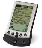
Palm Vx
The software consisted of the following components: - OS - Palm OS 4.1
- Navigation - Atlas 5.05i - http://www.gpspilot.com
- Databases - ThinkDB 2.5.0 - http://www.thinkingbytes.com
- Mail and data transfer - MultiMailPro 3.1 - http://www.actualsoft.com
- Other - iSilo, Calc, MemoPad, Hi-Note, Quicksheet
I will describe separately the characteristics of some programs. Atlas program allows you to work with a scanned map: calibrate it, introduce new coordinates, obtained on the ground, read the parameters from the GPS receiver, to celebrate the current position on the map. Since I had no cable connecting the GPS and the Palm, then I was interested in the manual entry of coordinates, the program allows a very easy to implement. It should be noted that this is not necessary to recalculate the coordinates in different systems as if we worked with the paper (in domestic kartoproizvodstve used primarily coordinate system Pulkovo 1942, and that gave GPS coordinates to the desired system, we must make some settings that understood not at once). Simply enter the current degrees, minutes and seconds (up to a thousand, while GPS gives accuracy to the tenth of a second). A 2-m removed from the area points can be assigned a card. Another, more convenient navigation software for the Palm I could not find. Here we should note that when converting to a format Palm, 500 metrovka eastern Elbrus (from B. Baksan to Elbrus, including the river valley Adil-su) occupies 1.8 MB of memory (16 shades of gray). At 4-6 MB of free memory Vx, it is quite significant size. Had to sacrifice unnecessary by the campaign software. It makes sense to think about buying a Palm 500 series with a color screen (although the 16 shades of gray to me quite enough).Memory of the PDA may expand by purchasing additional cards. Database ThinkDB. In this program, I had / kept record of a hike, as well as a database of films and removable frames. Ability to create linked tables and filters much easier life, but at the end of the campaign is very convenient to write the report. Is also always on hand captured the archive of films and pictures with descriptions. Those who work with the database (the database), it makes no sense to explain the advantages of this database, and those who do not work - it is easier to store their data in other software that is easier to understand (if there is interest, it is ready to send the constructed base for maintenance of the archive photographs and an archive of travel writing with comments). MultiMailPro - program to work with mail servers. While in Moscow and being an MTS subscriber, I use "mobile Internet" (0885), but when you use roaming, not all mobile operators support this service. So I used a cell phone as a modem, calling on the phone provider (7095, etc.) and transmitting data as if I had done the usual modem.
Bundle theory
Now directly on PDA, cell phone and GPS in the bundle. As mentioned, the handheld, I kept a diary travels, wrote letters, kept travel information. Also, there was flooded: a pair of books, toys, contact information, which I would need to travel, the layout of products, weight equipment, and other trifles. Since GPS does not belong to me, then connect the cable to the Palm I have not had the opportunity, although this possibility exists and should be used. Since I read the current GPS coordinates and altitude, introducing them to the Palm manually. The rest of the information I was not interested in (keeping the route, the return route to the starting point, average speed, sunrise and sunset, etc.). Continue to prepare and process the results from Palm's infrared port transferred to a cell phone, who played the role of a modem. It seemed very easy to send messages almost immediately, until all impressions are fresh and the data are outdated. Especially because all three devices are placed in one pocket. But it has its own peculiarities. The very first thing about what has to wonder - is a matter of supply. GPS uses 2 penlight batteries. According to the instructions of their missing for 20 hours of continuous operation. Thus, if work is continuous, the 14-day trip costs about 28 batteries. This option immediately sweeps for absurdity. Continuous GPS should work only in areas where we need to go back to the previously laid track. It's sporadic. For the entire campaign will calculate that for 10 consecutive hours GPS will be used a maximum of 2-3 times, all the rest of the time - the removal of point readings, that is included, measurements, recorded, turned off. We find that it will take 2-3 sets of batteries. A fresh set of insert into the device itself, and 2 spare sets with you (note that this is only theoretical calculation, the practice described below). Palm powered by a lithium-ion battery, so the question of charging. Power supply to the mountains to haul - meaning no no. In nature, there is a charger from a 9-volt battery. I bought it through a friend in America. It is known that in the cold lithium-ion battery runs down faster than normal temperatures. At this point how much the charge - it is not clear. Trips to the Moscow area have shown that for one day Palm discharged from 100% to 40-35% (if used within 2 hours and the temperature of +5 -5 `C). However, given the nonlinearity of the discharge / charge, one must assume that the charge will last for 3-4 days. Thus, we take 3 batteries for the Palm. Siemens S35 also uses a Li-Io battery, but battery charging for him there (I did not find, although I believe that you can do with their hands). He will work smoothly on the transmission of messages, plus a few phone calls. Disables all alarms and take it fully charged, although it can insure a second battery. It should also be noted that as the Palm, the phone has an infrared port, which is very important. If such a phone does not, then you should think about the cable that connects the two devices.
Experiment
I must say that the experiment was a success. Not everything went smoothly, but in general the band has worked well. Its application in field conditions may, however, I found out for himself a number of important points that must be reckoned with.How does it all behave in the real world? The first session, I gave the path in Nalchik on the train. The letter, written in the same place, went without problems. Time to link up with Moscow number and transmission of data totaled slightly more than a minute (about connection settings, see Appendix A at the end of the article). The next stage - the calibration card, that is, removing the first two conspicuous points in the pathway (a fork in B. Baksan and turn in the river valley Adil-su), brought them into the Atlas. To calibrate the map, you must enter the coordinates of 2 points (preferably located at opposite corners of the map). To this end, moving the stylus around the screen, move the map so that the required point hit the cross hairs centered on the screen.
 |
| Screen of Atlas |
The first unpleasant place - led the stylus on the screen (we move the map, not a point). This process is quite long and neudoben.Odnako no other choice. Thus, the card was tied to the locality. Arriving in climber camp Gian Tugan, opened the third point (the coordinates of the camp). The error turned out to 300-400 meters, which is a lot!
 |
| Error in the determination and / liter Jan-Tugan |
Calibrated map suburbs gave an error of 30-40 meters, which is much better than the results obtained in the Mountains (It is possible that the point on which I have calibrated, are too close. Ability to recalibrate I still will be when we are in the vicinity of Mount Elbrus). The second minus the program that you can not calibrate a map on a larger number of points (just over 2-meters), which would decrease the error bound. Another drawback found when we went on an acclimatization. Area of the map that fit on the screen is small, focus on it is not convenient. Have an all-time stylus to drag the map that is not convenient in itself, but in the cold twice. Simply have your hard copy maps, rolled in a transparent film of moisture (about other versions of Atlas, see Appendix B). Three days after the last charge (before departure), the battery level showed 20%, and I decided to recharge the Palm. During the night of Palm charged to 100% and kept this level throughout the next day, then gradually began to be discharged. Average daily time Palm was 2-3 hours, during which I wrote travel notes and one or two letters. In this case, the travel notes were introduced in the cold or the scorching sun, and the letters were written in the camp. At this stage, the way Palm has worked without any problems. A description of a waypoint takes no more than 2-3 minutes, and the main thing - it is a choice entries from the list and only a few stylus strokes describing the main points covered stretch of track. We must note one more feature - Palm stored either in the breast pocket or in the neck pouch - closer to the body to the ground while he was in heat, which contributes to better long-term conservation of charge. During the first half the way with GPS, I just rented the coordinates of points and put them in a Palm. If the weather was unsuitable for recordkeeping, or simply lacked the strength to write, then the waypoint stored in memory GPS and subsequently treated in the camp. Since the trip took place in one area, the recalibration of cards did not make sense. GPS works in this segment, a total of 5-10 minutes a day. It should be noted that, despite the mountainous terrain, GPS satellites are found for 1,5 - 2 minutes, considerably faster than on the streets of Moscow. With the weather would be nice to have a portable MP3 recorder, which can get rid of the writing of data in the current moment, and save the information to the camp, where it can be safely treated. Cellular network in the river valley Adil-su was absent, so the phone was not used. He was off in a backpack.The second part of the trip took place in the Baksan River valley through the village Terskol on the southern slope of Mount Elbrus. At the entrance to the village appeared Terskol network. To date, there shall be made only NC-GSM (North Caucasian GSM), even though I was hoping there connect to MegaFon. This statement does not support the "Mobile Internet", in this case working with a call option of roaming on the Moscow number provider and transmit data. When the first call attempt discovered an interesting fact - in bright sunshine data infraredu transmitted with an error, it was necessary to cover the ports by hand to start the transfer - too much sun. Transfer time was 4.3 letters slightly less than 2 minutes. When we were in Azau (start the cable car), I took one more point. Decided to recalibrate the map (for the moment, I had a point nearly opposite ends of the card), but either something is not done, or just went crashing - to calibrate the map is incorrect and no longer appear on screen. Restore the program is not allowed. At this stage, work with navigation software has ended. This is the biggest minus of the program - the inability to recover, and indeed, such a strange behavior in the calibration. As the lift to Elbrus mobile communication station "horizon" remained confident. Further, in order to conserve battery power, turn off the phone. Subsequent attempts to include not lead to success. At the height of the "home 11" (4000m) network is caught, but the phone is not registered on the network (a very strange fact, since his wife's phone register and we even got calls from his home, but due to her lack of services on the device "mobile office" , the data transfer failed). At times, caught a pair of Turkish networks, but registration is in them, too, is not happening. During the holiday or cooking dinner (at a height is a long process) in the camp, I am pleased to read the book (reader iSilo). This is another useful feature of the Palm:)
Conclusions
Here are the conclusions I have reached after 12 days of travel by these terms. GPS. I once again refused to buy it for several reasons. Use a bunch of GPS + Palm - convenient but not reliability, software and mechanical failures. (There is also a variant of the GPS and PDA based on WindowsCE. See the following list of references). Of course, it is interesting to know the height, position location, but not for $ 200. If you take the GPS alone, the domestic environment where kordinaty areas remain classified, or simply absent, and binding of cards, as a consequence, it becomes possible, it is of little use for high-grade orientation. There are two variants of a binding map, which ensured the applicability of the GPS 100%. The first - to tie the map at home, but then you have to know the coordinates of 2 or more points on the map the way forward, that in our country is practically impossible (admittedly, there are internet coordinates of some points, but they are negligible). Find the same card with information about the coordinates of the area, which could bind to these data is almost impossible. The second option - to calibrate ottsifrovannoy maps on the terrain. He is more suited to conditions in the countries of the CIS, but the question of reliability rejects this option. If using this option, only as a subsidiary. In the suburbs, killometrovki which lie in the network and information on the binding is present on the map (genshtabovskie card) - the question whether GPS is unequivocally in favor of GPS. Here you can still at home to calculate everything: the key points and distances, and road traffic ... In my opinion, if you take a card remote region, the binding of which is impossible because of the lack of information, while GPS is just an expensive toy, come to the aid of a compass and knowledge of cartography. GPS. I once again refused to buy it for several reasons. Use a bunch of GPS + Palm - convenient but not reliability, software and mechanical failures. (There is also a variant of the GPS and PDA based on WindowsCE. See the following list of references). Of course, it is interesting to know the height, position location, but not for $ 200. If you take the GPS alone, the domestic environment where kordinaty areas remain classified, or simply absent, and binding of cards, as a consequence, it becomes possible, it is of little use for high-grade orientation. There are two variants of a binding map, which ensured the applicability of the GPS 100%.The first - to tie the map at home, but then you have to know the coordinates of 2 or more points on the map the way forward, that in our country is practically impossible (admittedly, there are internet coordinates of some points, but they are negligible). Find the same card with information about the coordinates of the area, which could bind to these data is almost impossible. The second option - to calibrate ottsifrovannoy maps on the terrain. He is more suited to conditions in the countries of the CIS, but the question of reliability rejects this option. If using this option, only as a subsidiary. In the suburbs, killometrovki which lie in the network and information on the binding is present on the map (genshtabovskie card) - the question whether GPS is unequivocally in favor of GPS. Here you can still at home to calculate everything: the key points and distances, and road traffic ... In my opinion, if you take a card remote region, the binding of which is impossible because of the lack of information, while GPS is just an expensive toy, come to the aid of a compass and knowledge of cartography. Palm Vx - handy and useful thing, but not mandatory. I have not regretted its purchase, nor that he took it with him. As a navigation tool it should not be used or, more precisely - it can count as an adjuvant. Should remain the main map, compass and paper media information with a pencil (not pen, mind you). With the help of the CPC is very convenient to travel notes - they've just ottsifrovany, work in different natural and weather resistant, but the key information I would recommend to duplicate on paper. Single-cell battery "Krona" is enough for two full charge (6-10 days of travel) and a couple of days to maintain the charge at the level of 20-30% with continuous inclusion of charging the battery. When working Palm Vx 2-4 hours a day, charge it would have to once every 3-4 days. Knowing this, it is easy to calculate the consumption of batteries (as is charged on the more expensive battery-powered Energizer I have not tested). Thus for the 12 days I spent only 1 battery. In case of inclement weather (snow / rain) the use of Palm difficult (the screen may get wet, despite the protective film), but in camp he will replace books, toys, and a diary. For travel, I would recommend 505 series, which expands additional memory cards and has a color display (less significant). Tel. In any journey communication is needed, whether it is a portable radio or any other device. Mobile phone has now become the subject of daily life and to use it in a campaign solves an important problem of communication in a way. Nevertheless, the use of the phone has several features and constraints. Charge one battery was enough for exactly 12 days, provided that he worked a total of 3-5 hours, included in this 20-30 times (search the network when you turn on the most expensive operation for batteries) and stored it in a backpack, that is, when the temperature mode, the street (though at night the phone roamed into my sleeping bag when the temperature fell to -20 'C). Call home or write to friends, of course, great, but in our country, cellular communication is present mainly in large towns and tourist destinations are usually far away from them. Thus, using the phone at most impossible. If you and took with your phone, you should disconnect the battery, wrapped in a waterproof bag and put into the pocket in the heat. If you are traveling by car, or your route passes close to large settlements, the phone will surely come in handy. Online information (if we talk about e-mail or similar communication) is always expensive, but we must remember that it will leave you a pretty penny, the price for roaming is not the lowest, and one communication session lasts at least 2 minutes. The next trip I'll take just a Palm. Subject to the route near the settlement - the phone (in the mountains, most likely, I will not take it). GPS will stay with friends. If in my hands is a map which I can tie at home, then I'll try to take and GPS.
Appendix A
Connection Settings Palm Vx and Siemens S35
The phone must be switched on an infrared port (Menu - Setup - Fax / Data mode - IrDA). Do not forget, that also must be enabled services "mobile office" and "mobile Internet", if the operator supports this service.
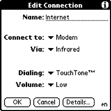
In the Palm's Preference configure the following: - Connection (create your)
- Name: Internet
- Connect to: Modem
- Via: Infrared
In the Network: - Service: Mobile
- User name: your username at the ISP
- Password: your password from your ISP
- Connection: Internet
- Phone: +7095 _nomer_provaydera (for Moscow)
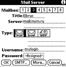
In MultiMail menu in the Option select Network Panel. Next, select the created connection (Mobile).
There select the menu Server. - Title: server name (for example, Elbrus)
- Server: your mail server (for example, mail.msm.ru)
- Type: pop (or protocol that supports your mail server)
- Username: Your username on the server
- Password: your password on the server
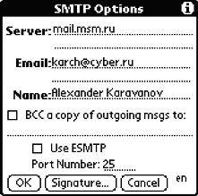
Next, press the button at the bottom of SMTP.
In the entry screen: - Server: your SMTP server (for example, mail.msm.ru)
- E-mail: Your e-mail (for example, karch@cyber.ru)
- Name: your name
- Then click OK. Basic settings are done.
Appendix B
Using Atlas (an overview of possibilities)
From the foregoing it is clear that it is not necessary to use navigation with PDA and GPS, as the main option. Nevertheless, this option may be a good complement to the road. Hiking hiking when the speed of your movement is low (you're in the same scale maps), this decision will not be significant, however, if you travel by bike or by car (not on main roads, where the atlas and so clearly the location) the program Atlas will be very useful. The main advantage of the program is the fact that you can put any card, pre-scanned and converted to the format of the program, and calibrate it during the trip. As we move along the route, you can make adjustments in the calibration map, introducing a new anchor point. If you create a map of different scales and pour them into the Palm, bind to the same point, the program lets you quickly switch between them, so you can mashtabirovat map in the program (very convenient when traveling by bike on forest roads). Along with this, the program supports several types of waypoints (travel, cities, airports and destination points), several maps and databases of points. Reads data from the GPS by cable, and if do not have cable, you can enter data manually. Nevertheless, the program has several flaws. The main and most critical shortcoming in the program remains the problem of card recovery after an erroneous calibration. Have a backup version of the card does not allow the limitation of the CPC on memory (Option Palm Vx). Thus, in the event the program is completely unusable. Also not very convenient to carry a map with stylus on the screen especially in field conditions. Despite these shortcomings, the program remains a good helper to navigate.And it is hoped that the next version of the program will be put in mechanisms to restore card after the crash. The authors, translation:

